Palleranda Boat Ramp
Palleranda boat ramp is located towards the end of Cape Palleranda Road and is an ideal spot for launching a sea kayak. The GPS coordinates for the boat ramp are S19 11 50.1 E146 46 28.2
Google Maps Link.
The Palleranda boat ramp provides easy access to a gently sloping sandy beachfront, which makes for easy and hassle free kayak launches and landings. It is an ideal launch site for trips to Magnetic Island, Shelly Beach, Bay Rock, Middle Reef, and exploring the Townsville coastline north of the Strand.

This sand is not a problem for most vehicles with good ground clearance, but if you are concerned, you could stop your vehicle just before this sand mound, to load or unload your kayak. Alternately you could load your kayak onto a kayak trolley and roll it the short distance from the carpark to the shoreline.

There are no taps or other facilities available directly at the boat ramp or carpark area, but the park located approximately 100m to the south of the boat ramp has toilets, BBQ facilities and most importantly freshwater taps suitable for washing down kayaks and gear.
Landmarks and Hazards

The two brightly
coloured amenity blocks with their distinctive yellow walls and bright orange
roofs serve as a useful
navigational landmark, giving you a solid reference point to aim for when returning to the boat ramp. They can be
easily identified from a kayak approximately 5km away.
 Approximately 260m NE from the boat ramp is a hazard marker buoy
indicating a shallow rocky area with exposed sections of debri at low
tide. Keep about 50 m clearance from this buoy to avoid the submerged
hazard. There are also baited shark drum lines set just off the shoreline.
Approximately 260m NE from the boat ramp is a hazard marker buoy
indicating a shallow rocky area with exposed sections of debri at low
tide. Keep about 50 m clearance from this buoy to avoid the submerged
hazard. There are also baited shark drum lines set just off the shoreline.
 Following the coast line from Palleranda to Rowes Bay is a good training route for beginners, wanting to get experience kayaking in waves. The return trip distance is also approximately the same as a one way crossing to Picnic Bay or West Point on Magnetic Island and is a good way to judge your fitness level before attempting an island crossing for the first time.
If you enjoy good quality coffee, a stop off at the Fuel Cafe at the Rowes Bay shops on your way back from Palleranda will not disappoint.
Google Maps Link.

The Palleranda boat ramp provides easy access to a gently sloping sandy beachfront, which makes for easy and hassle free kayak launches and landings. It is an ideal launch site for trips to Magnetic Island, Shelly Beach, Bay Rock, Middle Reef, and exploring the Townsville coastline north of the Strand.

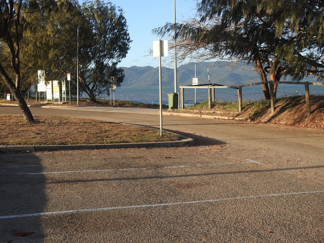
The boat ramp has an unusual design, made up of small interlocked
concrete blocks with deep wide grooves set between them. As there are no raised side walls, sand tends
to build up on top of the ramp in a mound just above the high tide
level.
 |
| (Photo courtesy of Gerry Lyn from Townsville Kayak Club ) |
This sand is not a problem for most vehicles with good ground clearance, but if you are concerned, you could stop your vehicle just before this sand mound, to load or unload your kayak. Alternately you could load your kayak onto a kayak trolley and roll it the short distance from the carpark to the shoreline.

There are no taps or other facilities available directly at the boat ramp or carpark area, but the park located approximately 100m to the south of the boat ramp has toilets, BBQ facilities and most importantly freshwater taps suitable for washing down kayaks and gear.
Landmarks and Hazards

 Approximately 260m NE from the boat ramp is a hazard marker buoy
indicating a shallow rocky area with exposed sections of debri at low
tide. Keep about 50 m clearance from this buoy to avoid the submerged
hazard. There are also baited shark drum lines set just off the shoreline.
Approximately 260m NE from the boat ramp is a hazard marker buoy
indicating a shallow rocky area with exposed sections of debri at low
tide. Keep about 50 m clearance from this buoy to avoid the submerged
hazard. There are also baited shark drum lines set just off the shoreline. 
If you enjoy good quality coffee, a stop off at the Fuel Cafe at the Rowes Bay shops on your way back from Palleranda will not disappoint.
Comments
Post a Comment