Garmin Etrex 20x GPS
The Garmin Etrex 20x is a lightweight and compact GPS unit designed and constructed to be waterproof to IPX7 standards and holds up to a bit of rough handling. The unit is powered by two AA batteries, which provide sufficient power for 2 full days of kayaking. Furthermore this unit has mapping capabilities, is highly customisable and has all the functionality a kayaker could want in a GPS unit.
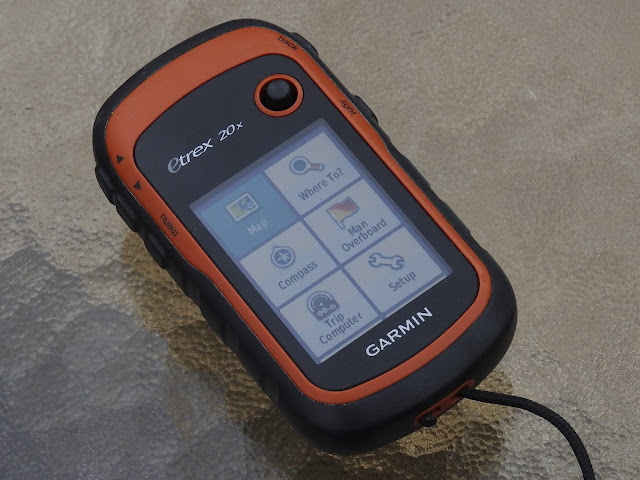 The unit has a 3.5 x 4.4 cm colour display which is clean and crisp and can be backlit
to improve visibility. There are five buttons placed along the vertical edges and a
joystick style thumb button mounted on the front face for scrolling, inputting and selecting. When I was choosing a GPS device for kayaking, I ruled out the touchscreen devices
right away as touchscreens don’t work very well when wet and they also have a lower
battery life.
The unit has a 3.5 x 4.4 cm colour display which is clean and crisp and can be backlit
to improve visibility. There are five buttons placed along the vertical edges and a
joystick style thumb button mounted on the front face for scrolling, inputting and selecting. When I was choosing a GPS device for kayaking, I ruled out the touchscreen devices
right away as touchscreens don’t work very well when wet and they also have a lower
battery life.
 There are rubberized covers on all of the buttons along with sealable covers for the battery compartment and USB port. The waterproofing measures are effective as this unit has held up to several capsizes and regular salt water splashes. There is a built-in mounting spine on the back cover that attaches to the various Garmin Etrex mounts and access to the battery compartment is as simple as turning the D shaped gate screw and removing the back cover plate.

A MicroSD card slot for storing maps and additional data storage sits beneath the batteries while the Mini USB port is protected under the top rear flap. Both compartments seal well and I haven't had any problems with water getting in.
 Battery Life
The device runs on 2 AA sized batteries. These batteries can be standard Alkaline batteries or rechargeable types such as NiMH or Lithium Ion batteries. The device has a low battery warning which is displayed a few minutes before the batteries are depleted and there is also an effective Battery Saver Mode. Click for a details on Battery Saver mode
GPS Signal
A GPS is really only as good as the signal it can receive, and the Etrex performs strongly in that regard. It is capable of utelising both GPS and GLONASS satellite networks for fast and accurate position fixes. The average Time To First Fix, for this unit is 57 seconds in a cold start scenario and 13 seconds for a warm start.

The unit is able to receive WAAS and EGNOS correction signals, however Australia and many other countries do not support or have the infrastructure in place to relay these signals. Outside of America or Europe this option should not be selected as it will only waste battery power looking for a signal that does not exist. There is also the option to disable the GLONASS satellite receiver to save on battery power.
 The screen is a bit small for planing routes or viewing close up map detail. It’s much easier to plan your
routes in the Homeport program and send them to the device instead. The maps can be scaled to unit sizes ranging between 5m to 800 km and there is a noticeable redrawing delay when panning past the current screen edge or zooming in or out of he map. The level of detail shown on the BlueChart maps can be set by the user and chart features will be appropriately displayed or hidden as you zoom in or out respectively.
The screen is a bit small for planing routes or viewing close up map detail. It’s much easier to plan your
routes in the Homeport program and send them to the device instead. The maps can be scaled to unit sizes ranging between 5m to 800 km and there is a noticeable redrawing delay when panning past the current screen edge or zooming in or out of he map. The level of detail shown on the BlueChart maps can be set by the user and chart features will be appropriately displayed or hidden as you zoom in or out respectively.
 When navigating to a waypoint or route, a course indicator will be displayed which will point in the direction to the waypoint or the next point in the route. You can select between three course pointers including a Course Deviation Indicator as well as customising the data fields shown on screen.
 When not navigating to a waypoint or route, certain data fields will remain blank until a navigation point is selected. The trip data displayed is calculated from the last time the trip counters were reset, therefore if you want accurate trip data for a specific trip it is essential to reset the trip counters in the Setup / Reset page just prior to setting off.
 The design I came up with allows the unit to be positioned at the optimal viewing angle and keeps the unit low on the deck so as not to interfere with paddling. The mounting bracket is easily removed, transferable to other kayaks and will float the GPS unit should it fall overboard.
 Conclusion
The strengths of this unit are numerous, but most notable are the waterproofing, compact size, and exceptional battery life. The solid performance of this unit with the addition of a high quality marine mapping charts make it a stand out choice for sea kayaking purposes. The navigation pages are straight forward to use and they can easily be customised to suit specific requirement and preferences. Although this unit only has a fairly basic set of features by modern standards, it has all the functionality required for sea kayaking and most importantly this unit has proved itself to be extremely reliable time after time in all conditions.
If I had to pick aspects that fall short of the mark, they all revolve around the operation speed of the unit. It takes a while to turn on, map scrolling is clunky and using the built in keyboard can be frustratingly slow. These issues are more of a annoyance than major drawbacks. Other areas where it would lose serious points, if not for alternative options being easily available, are the built in base map and the poorly designed kayak mounting brackets on offer by Garmin.


A MicroSD card slot for storing maps and additional data storage sits beneath the batteries while the Mini USB port is protected under the top rear flap. Both compartments seal well and I haven't had any problems with water getting in.
 Battery Life
The device runs on 2 AA sized batteries. These batteries can be standard Alkaline batteries or rechargeable types such as NiMH or Lithium Ion batteries. The device has a low battery warning which is displayed a few minutes before the batteries are depleted and there is also an effective Battery Saver Mode. Click for a details on Battery Saver mode
GPS Signal
A GPS is really only as good as the signal it can receive, and the Etrex performs strongly in that regard. It is capable of utelising both GPS and GLONASS satellite networks for fast and accurate position fixes. The average Time To First Fix, for this unit is 57 seconds in a cold start scenario and 13 seconds for a warm start.

The unit is able to receive WAAS and EGNOS correction signals, however Australia and many other countries do not support or have the infrastructure in place to relay these signals. Outside of America or Europe this option should not be selected as it will only waste battery power looking for a signal that does not exist. There is also the option to disable the GLONASS satellite receiver to save on battery power.
Routes, Tracks and Waypoints
The unit can hold up to 2,000 individual waypoints and 200 routes in it’s internal memory. The device accurately records tracks and waypoints without issue and allows all data to be extracted to a computer via USB cable. There are options to show or hide tracks on the map screen as well as reversing recorded tracks or routes if required. Proximity and warning alerts can be set if required as well as waypoint averaging and a MOB function. Garmin provides a free computer program called "HomePort" that’s a great tool for planning routes and then loading them onto the unit.Mapping Function
The world wide base map supplied with the device is very basic and not suitable for navigation, but you can upgrade by buying Garmin’s BlueChart maps on a micro SD card. These maps are of good quality but expensive to purchase. A quick eBay search will find a few alternate vendors that offer the exact same mapping packages minus the fancy packaging for a fraction of the cost. The unit also allows the loading of custom maps.
Compass Page
The eTrex 20 does not have a electronic compass, instead it calculates a vector between your last location and your current location to give a direction of motion. Therefore the unit needs to be moving and receiving satellite signals in order to give an accurate reading. When standing still the compass will display its last known direction of travel. When navigating to a waypoint or route, a course indicator will be displayed which will point in the direction to the waypoint or the next point in the route. You can select between three course pointers including a Course Deviation Indicator as well as customising the data fields shown on screen.
Trip Computer
The trip computer screen is a highly customizable analytical tool that can be used as an additional navigation screen. You can choose from a list of functions to display in the data field boxes and it is also possible to change the layout and size of the data fields to suit. Click the link for a list and brief explanation of available Data Fields. When not navigating to a waypoint or route, certain data fields will remain blank until a navigation point is selected. The trip data displayed is calculated from the last time the trip counters were reset, therefore if you want accurate trip data for a specific trip it is essential to reset the trip counters in the Setup / Reset page just prior to setting off.
 Additional Useful Features
- The Zoom in and zoom out buttons can be used to navigate menu lists a page at a time.
- A double tap on the menu button will access the main menu from any page.
- Press and holding the menu button it will bring up the "Where to Menu".
- Press and holding the thumb stick will mark a waypoint at your current position.
Kayak Mounting Options
Garmin make a selection of mounting brackets for the Etrex series but I found their mounts for installing to a kayak to be disappointing in both design and function. For that reason I decided to make my own mounting bracket.
 Conclusion
The strengths of this unit are numerous, but most notable are the waterproofing, compact size, and exceptional battery life. The solid performance of this unit with the addition of a high quality marine mapping charts make it a stand out choice for sea kayaking purposes. The navigation pages are straight forward to use and they can easily be customised to suit specific requirement and preferences. Although this unit only has a fairly basic set of features by modern standards, it has all the functionality required for sea kayaking and most importantly this unit has proved itself to be extremely reliable time after time in all conditions.
If I had to pick aspects that fall short of the mark, they all revolve around the operation speed of the unit. It takes a while to turn on, map scrolling is clunky and using the built in keyboard can be frustratingly slow. These issues are more of a annoyance than major drawbacks. Other areas where it would lose serious points, if not for alternative options being easily available, are the built in base map and the poorly designed kayak mounting brackets on offer by Garmin.
Comments
Post a Comment