Cape Cleveland Light House
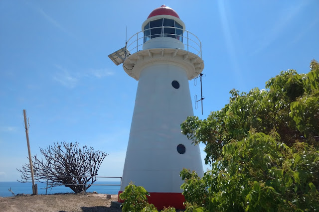
The Cape Cleveland Lighthouse is an active, heritage-listed lighthouse marking the northern point of Cape Cleveland and the hazardous reefs and rocks situated on the approach to Cleveland Bay. The lighthouse is located approximately 21.2 km from the South Townsville Boat Park or 25.6 km from the Palleranda Boat Ramp and the beach access to the lighthouse has the following GPS coordinates S19 11 05.8 E147 00 54.4 Google Map Link
The lighthouse is located on a northerly facing promontory approximately 53 m above sea level and displays a flashing multi coloured sector light every 7.5 seconds. The red sector which projects into Bowling Green Bay signifies the hazardous navigational area between Salamander Reef and Four Foot Rock.
There is a distinct lack of shaded areas on the beach and the surrounding terrain, but fortunately there are welcoming shady areas located around the buildings at the top. Access to the lighthouse is via a moderately steep concreted path approx 500m long, which snakes around the headland up to the lighthouse and associated buildings.
About midway up the path there are some amazing views. The above photo is looking out towards Bowling Green Bay, and the photo below is looking towards Cleveland bay.
Looking down towards the beach area. Note: The submerged rocks formations just off the beach area which may cause a hazard during very low tides. The channels between them are marked with posts and small mooring buoys and are easily identified.
 Stunning view from the top of Cape Cleveland.

The lighthouse has been well maintained and was converted to solar power in 1987, shortly before becoming fully automated. Unfortunately the lighthouse keeper residences and associated buildings and structures are in a fairly poor condition.

Old decrepit fuel tanks which once stored the kerosene required to power the original lights for the lighthouse and the lead Light. These tanks would have became redundant in 1926 when both lights were converted to an acetylene gas powered lamps.

The Head Keepers Cottage, with the lighthouse in the background. The front of this building has been restored and turned into a museum showcasing the history of the area. The path leading down from the lighthouse goes to the site of the Lead Light.
 The second lighthouse keepers residence is in a poor state of repair, showing severe termite damage and has been completely boarded up.
Trip Planning Considerations
History of the Lighthouse
The need for a lighthouse at Cape Cleveland arose with the proclamation of Cleveland Bay as a port of entry in 1865. The construction of the lighthouse and 2 keepers residences were completed in December 1879. A Mechanically powered flying fox was setup next to the lighthouse and was used to hoist fuel and supplies up from the beach. A cart would then be rolled down a tram line to deliver supplies to the residences and fuel to the Lead Light.
In 1926 the lens was replaced in the lighthouse and the light sources for both the lighthouse and the Lead light were converted from kerosene to an acetylene gas lamp.
During World War II the lighthouse served as an observation post for the nearby, allied base in Townsville. The building of an observation platform, a radar hut and a powerhouse were constructed at the site for this purpose, though only ruins of the military installments remain today. The lighthouse kept on operating throughout the war years.
The lighthouse is located on a northerly facing promontory approximately 53 m above sea level and displays a flashing multi coloured sector light every 7.5 seconds. The red sector which projects into Bowling Green Bay signifies the hazardous navigational area between Salamander Reef and Four Foot Rock.
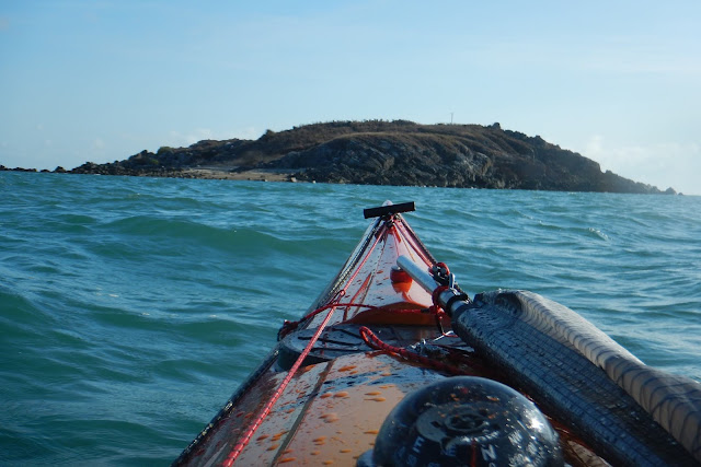
The Bowling Green Bay side of the promontory has a very rugged and scenic coastline which is great for photographing and exploring in close with a kayak during calm to moderate conditions. Access to the lighthouse is on the Cleveland Bay side of the promontory where there is a gentle sloping sandy beach approximately 300m long, great for landing a kayak.
There is a distinct lack of shaded areas on the beach and the surrounding terrain, but fortunately there are welcoming shady areas located around the buildings at the top. Access to the lighthouse is via a moderately steep concreted path approx 500m long, which snakes around the headland up to the lighthouse and associated buildings.
About midway up the path there are some amazing views. The above photo is looking out towards Bowling Green Bay, and the photo below is looking towards Cleveland bay.
Looking down towards the beach area. Note: The submerged rocks formations just off the beach area which may cause a hazard during very low tides. The channels between them are marked with posts and small mooring buoys and are easily identified.
 Stunning view from the top of Cape Cleveland.
The lighthouse has been well maintained and was converted to solar power in 1987, shortly before becoming fully automated. Unfortunately the lighthouse keeper residences and associated buildings and structures are in a fairly poor condition.

Old decrepit fuel tanks which once stored the kerosene required to power the original lights for the lighthouse and the lead Light. These tanks would have became redundant in 1926 when both lights were converted to an acetylene gas powered lamps.

 The second lighthouse keepers residence is in a poor state of repair, showing severe termite damage and has been completely boarded up.
There was a separate lead light located approximately 100m from the lighthouse at a
bearing of 111degrees. The lead light was used to create a range showing the safe passage between Twenty
Foot Rock and Four foot Rock. The tram track shown, was used to lower a cart loaded with fuel to resupply the lead lights fuel source. The lead light was decommissioned and removed in the 1980's.
Trip Planning Considerations
- Allow 3.5 hours paddling time each way in good conditions from South Townsville boat ramp.
- The waters surrounding Cape Cleveland are designated a GBMPA Yellow zone and fishing is permitted.
- The lighthouse is managed by AMSA but the surrounding land and buildings are leased and maintained by Ray and Sue Boundy. Camping or day visits are by permission only. Contact can be made via mobile ph 0409879304 or email rsboundy@bigpond.com
- The rain water tanks beside the old lighthouse keepers residences do contain water and have working valves to dispense it. I would highly recommend sterilizing or boiling the water if you need to drink any of it.
- Mobile phone reception is available.
History of the Lighthouse
The need for a lighthouse at Cape Cleveland arose with the proclamation of Cleveland Bay as a port of entry in 1865. The construction of the lighthouse and 2 keepers residences were completed in December 1879. A Mechanically powered flying fox was setup next to the lighthouse and was used to hoist fuel and supplies up from the beach. A cart would then be rolled down a tram line to deliver supplies to the residences and fuel to the Lead Light.
In 1926 the lens was replaced in the lighthouse and the light sources for both the lighthouse and the Lead light were converted from kerosene to an acetylene gas lamp.
During World War II the lighthouse served as an observation post for the nearby, allied base in Townsville. The building of an observation platform, a radar hut and a powerhouse were constructed at the site for this purpose, though only ruins of the military installments remain today. The lighthouse kept on operating throughout the war years.
- In 1953 the two residences, as well as other sheds and building, were replaced.
- In the 1980s a new power house was constructed and the Lead Light was decommissioned.
- On 19 September 1987 the light was converted to solar power.
- December 1987 the light station was de-manned.
- The solar power was upgraded to its current setup on 12 July 1994.


Comments
Post a Comment