Posts

Showing posts with the label Kayak Camping

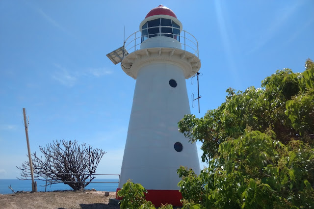
Cape Cleveland Light House
Image
The Cape Cleveland Lighthouse is an active, heritage-listed lighthouse marking the northern point of Cape Cleveland and the hazardous reefs and rocks situated on the approach to Cleveland Bay.  The lighthouse is located approximately 21.2 km from the South Townsville Boat Park or 25.6 km from the Palleranda Boat Ramp and the beach access to the lighthouse has the following GPS coordinates  S19 11 05.8  E147 00 54.4   Google Map Link The lighthouse is located on a northerly facing promontory approximately 53 m above sea level and displays a flashing multi coloured sector light every 7.5 seconds.  The red sector which projects into Bowling Green Bay signifies the hazardous navigational area between Salamander Reef and Four Foot Rock. The Bowling Green Bay side of the promontory has a very rugged and scenic coastline which is great for photographing and exploring in close with a kayak during calm to moderate conditions.  Access to the lighthouse is ...
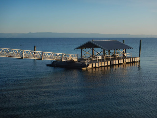
Yanks Jetty

Image
Yanks Jetty is the name given to a floating pontoon positioned approximately 2km from the southern tip of Orpheus Island.   This area was the original site of an American WW2 Degaussing (demagnetising) Station for allied ships and submarines, hence the name.  It is located approximately 20.5 km from the Forrest  Beach Boat Ramp and has the following GPS coordinates  S18 39 04.2 E146 29 12.0  Google Maps Link. The pontoon consists of a 18 x 9 metre platform with an attached gangway connecting it to the beach.  There is a centrally shaded area containing several picnic tables and a snorkeling platform with easy access ladders.  The entire structure is moored approximately 55m from the shoreline on the edge of the surrounding reef.   There is a National Parks Camp Site located approximately 200m south of the pontoon where basic facilities such as a composting pit toilet and picnic tables are provided.  There used to be a gas BBQ at the c...

Loading a Sea Kayak for an Expedition

Image
Despite their relatively small size, a sea kayak can carry an amazing amount of gear. One of the big draws of sea kayaking is that you can go and explore some of the most beautiful, wild and remote parts of the coast, for days or even weeks at a time and still live in relative comfort. The good thing about packing a sea kayak is that there are three hatches to stuff full of gear and there will usually be enough free space to pack a few luxuries (a little extra weight will still float just fine). The bad thing is the hatches are awkward shapes and nothing fits in them easily. Keeping Your Gear Dry The sealed hatches of a modern sea kayak are generally water-tight. However, leaks do happen. Your first line of defense against water ingress is to check that your kayak hatches are in good order and correctly fitted before setting off.  As a secondary precaution, dry bags or waterproof containers can be utilised to keep your gear dry. I use the general rule that if you ...

Lovers Bay

Image
Lovers Bay is a small  secluded bay on the northern side of Magnetic Island between Five Beach bay and Horseshoe Bay.  It is located approximately 14.3 km from the Palleranda Boat ramp  and has the following GPS coordinates  S19 06 19.7  E146 49 57.7   Google Maps Link Lovers Bay is only accessible by boat and has a shoreline consisting mostly of large boulders surrounded by trees and undergrowth.  There is a very small sheltered section of beach which is ideally suited for landing a kayak or small boat. The bay is located on the edge of the GBMPA Green Zone, so fishing is not permitted within the bay, but once you round the northern headland you are outside of the Green zone and fishing is allowed.  There is a small stretch of sand and coral rubble above the high tide zone  where a tent could be set up. Climbing over the boulders on the northern headland presents some excellent photo opportunities as well as exposing a contin...