Posts

Showing posts with the label Halifax Bay

Yanks Jetty

Image
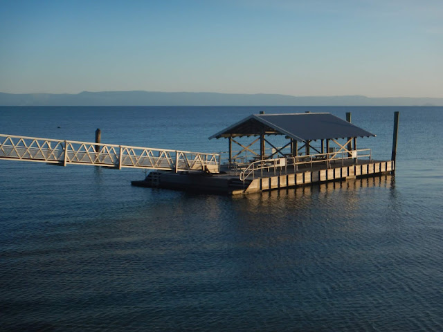
Yanks Jetty is the name given to a floating pontoon positioned approximately 2km from the southern tip of Orpheus Island.   This area was the original site of an American WW2 Degaussing (demagnetising) Station for allied ships and submarines, hence the name.  It is located approximately 20.5 km from the Forrest  Beach Boat Ramp and has the following GPS coordinates  S18 39 04.2 E146 29 12.0  Google Maps Link. The pontoon consists of a 18 x 9 metre platform with an attached gangway connecting it to the beach.  There is a centrally shaded area containing several picnic tables and a snorkeling platform with easy access ladders.  The entire structure is moored approximately 55m from the shoreline on the edge of the surrounding reef.   There is a National Parks Camp Site located approximately 200m south of the pontoon where basic facilities such as a composting pit toilet and picnic tables are provided.  There used to be a gas BBQ at the c...

Northern Palm Group Map

Image
I have modified screen shots of electronic navigational charts to show features relevant to sea kayakers while removing most of the clutter which over complicate standard charts.  These modified charts are designed to be scaled up  and printed in landscape orientation on A4 size paper. Northern Palm Group Click on the links below to see other related map sections for this area :

Bay Rock

Image
Bay Rock is a small rocky islet off the coast of Magnetic Island in North Queensland. It is approximately 9.3 km from the Palleranda Boat ramp or 17 km from the Strand Beach launch site and has the following GPS coordinates S19.117505  E146.753006  Google Maps Link. As the name would suggest Bay Rock is a small rocky islet with an approximate circumference of 650 metres and rises steeply to approximately 20 metres above sea level.  There is a shallow reef area and a rocky beach on the western side.  The rest of the islet is surrounded by deep water and rugged rock faces. The tidal currents around Bay Rock and West Channel are shown on the above image  You can save a lot of energy on this trip by coordinating your travel legs with the appropriate tidal phase.  Peak tidal flow of up to 2 km/h during large tides are common. There is a small section of beach which has been cleared of rocks and is suitable for landing a kayak or small bo...

Hallifax Bay Map ( Cape Palleranda to Balgal Beach )

Image
I have modified screen shots of electronic navigational charts to show features relevant to sea kayakers while removing most of the clutter which over complicate standard charts.  These modified charts are designed to be scaled up  and printed in landscape orientation on A4 size paper. Cape Palleranda to Balgal Beach   Detailed View of Rattlesnake and Herald Islands  Rattlesnake Island Satellite Image Herald Island Satellite Image  Acheron Island Satellite Image